Sea Turtle Satellite Tracking | Aitkanti

wwf-marinas stclog_sm Karumbe_logo logo-CNRS_sm Logocepe_sm logoiucn_sm adopt_now_sm

Zoom In  |  Animated Map  |  Project & Turtle Information  |  Google Earth Tracking File
Project Turtles: Aitkanti | Apotilï | Caroline | Choroeüo | Cristina | Fermina | Gurí | Kawana | Ibélice | Ibonga | Idun | Jamur | Marina | Palana | Quasimoda |Rickie | Romana | Shelldon | Victoria | Yalimapo | Zoe 

suriname-aitkanti-region

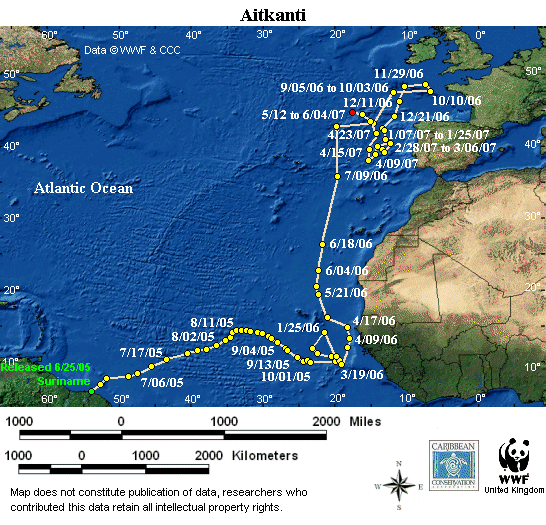
Cumulative distance traveled: 14,330 km (8,905 miles)

Distance covered since last location: NA

Maximum dive depth: 840 m (2,756 feet)

Maximum dive depth since last location: 51 m

Notes: Aitkanti is in the same area off the European coast. A recent dive lasted 10 minutes. Straight line distance from release site is 5,593 km.

Sea floor depth: less than 250 m


Cumulative Distance refers to how far the turtle has actually travelled since it was first tagged. Straight Line Distance refers to the distance between where the turtle was first tagged and its current position in a straight line.

Please note: The presentation of data here does not constitute publication, and the researchers who contributed this data retain all intellectual property rights.
Note to IE users: If the Animated Map does not work, you need to open Internet Explorer > Tools > Internet Options > Advanced, scroll down to Multimedia and check “Play animations in web pages” Click OK. Close and reopen IE.

Map courtesy of Dan Evans, Sea Turtle Conservancy. Data © WWF and Partners.
This map is updated with new points as soon as they are received by the Sea Turtle Conservancy. The red location point is the most recent location received for this turtle. If the red point is more than two months old, then the transmitter is most likely no longer working.

Map may be reproduced for educational or conservational purposes with the following credit: “Data © WWF and STC, map courtesy of STC.”